Maritime Rally Passage Discussion
Experienced Maine coastal cruisers will likely already be familiar with strategies for sailing in fog. The Cruising Guide to Nova Scotia describes a "thicker, wetter and colder" fog both in the Gulf of Maine and along the outer coast of Nova Scotia. In this region, fog also tends to come up with relatively short or no warning, although weather models can now be used for predictions for a day or two ahead. Radar reflectors are a must-have, and a thorough understanding of sailing with radar and AIS is necessary. Crew should be outfitted with good foul weather gear, capable of withstanding the conditions similar to, or worse than the first few days of the Caribbean Rally in November. Tidal range considerations during this rally are less of an issue than when cruising the coast of Maine or the East coast of the Bay of Fundy. However, a discussion of fixed and tidal currents around the mouth of the Bay of Fundy and at Cape Sable is warranted. During the crossing of the Bay of Fundy the effect of the ebb and flood tides tend to cancel each other out every 12 hours, so at our usual average 6kts boat speeds you are typically going to experience one cycle of both favorable and adverse current. Within the Bay of Fundy a strong south or southwest wind blowing against an ebb tide can kick up a mean sea, and such conditions can be be avoided by having good weather routing. South of Cape Sable, the combination of the Labrador current flowing south to SW in this region, plus the flooding tidal flow into the Bay of Fundy can also make eastward progress slow and sometimes challenging. Therefore, departure timing from the rally's starting points is based on the local weather conditions expected (especially during the 12 hours of inevitable strong current exposure), rather than about the exact timing of that exposure with respect to the anticipated tide cycle.
For more understanding of the tidal currents encountered, refer to the Atlas of Tidal Currents: Bay of Fundy and Gulf of Maine. Near Cape Sable and all along the East coast of Nova Scotia, sailors are advised to stay well offshore since the harbors are well inside of dangerous obstructions. A system of buoys marking the inshore dangers all along the coast must be heeded. Approaching Cape Sable from Maine, one must be careful of rock ledges and tidal rip currents. Stay at least 2 NM south of Blonde Rock and well below areas shown as “rips”. Offshore and inshore, many man-made floating objects are equipped with stationary radar reflectors which can be both helpful and confusing. For example, coming up the Shelburne River one will encounter several large fish-raising floats that are acres wide (see Harbor Approaches pages. Prevailing winds from the Northeast US Coast to Nova Scotia at this time of year are from the South and Southwest, so, whether departing from Southern New England or from Rockland, ME, downwind sailing or motorsailing may be encountered when traveling to the NE. Winds do swing around a lot all summer – early to mid-summer are mostly warm fronts, and late summer (mid-August to mid-Sept) are cold fronts. Prevailing does not mean steady or only, but just the largest percentage of time. Those frontal patterns give a mix of winds from all directions, and if one would rather sail, you can visit an anchorage and wait a day or two for more favorable winds – that works well trying to get back to the SW – boats that are on a schedule complain about bashing back to the SW - they don’t have to if they stay flexible. Boats going NE in the summer should plan to wait a day if winds are from N-NE-E. The schedule we’ve laid out moving NE has an extra day here or there for delays, and then we suggest moving a longer distance when one has favorable weather, including an additional over-night, to get to the Bras D’Or lake in reasonable time – the objective. One potential advantage to departing from Rockland is a slightly higher chance of a nice beam or broad reach toward Cape Sable. Wind speeds are light during August, averaging between 8 and 10 knots in the summer, with some days in the teens, and others in the light and variable range. A nice light air sail is welcome when traveling NE along the east coast of Nova Scotia in summer, but if the wind shifts, strategies to avoid a lee shore are critical here. On the return voyage, winds on the nose are more likely, unless one stays flexible and rides the backside of early cold fronts in late August or early September. Fortunately, in the return direction, once you are past Cape Sable there is good opportunity to adjust your course as needed. For example, for the Halifax mid-coast region in early August, the wind-rose shows: N, NE or E 25% SE 10% S, SW 45% NW or W 20% Once in the protected waters of the Bras d'Or Lake an entirely different world of cruising awaits you: Warm water sailing with little to no fog! A tidal range measured in inches, not feet! Beautiful anchorages with excellent holding! And good facilities including world class services in the final port of Baddeck. Anywhere along the route you may choose to travel in close company with another vessel in the fleet – a "buddy boat" or grouping of boats. These arrangements between vessels can be made during pre-departure activities or anywhere along the trip. Being part of a Salty Dawg Rally ensures the best expert input on departure and offshore strategies, boats nearby for assistance, and staying connected with other vessels through required VHF radio, optional email capability, SSB or satellite phone. Additional information will be provided by the Rally management team in the weeks leading up to the Rally. Rally participants will have access to Chris Parker weather and routing updates, and Shoreside Coordinator communications and news if equipped for offshore communications. Boat position is shown continually for family and friends on our online tracking map (if equipped for reporting position). The SDSA unites experienced ocean sailors with developing cruisers to broaden their blue water horizons. All Salty Dawg rallies and events are led by seasoned sailors who volunteer their time and knowledge to help cruisers realize their dreams. If you would like to join us as a volunteer, we would love to benefit from your passion, personality, and expertise as we plan future events. Click here to volunteer.
|
 The Maritime Rally departs Rockland, ME and the Cape Cod Canal area in mid-July, weather permitting. Participants should be flexible enough to allow for a delay in departure due to weather. At this time of year weather considerations still include the possibility of tropical storm or hurricane development, which should be avoidable by consulting long term North Atlantic forecasts. This route does overlap the first leg of a Transatlantic crossing to Northern Europe that is popular in the early summer, but it is well south and west of any iceberg risk. However, traffic and fog are two significant factors to contend with when making passage across the Gulf of Maine and the Bay of Fundy.
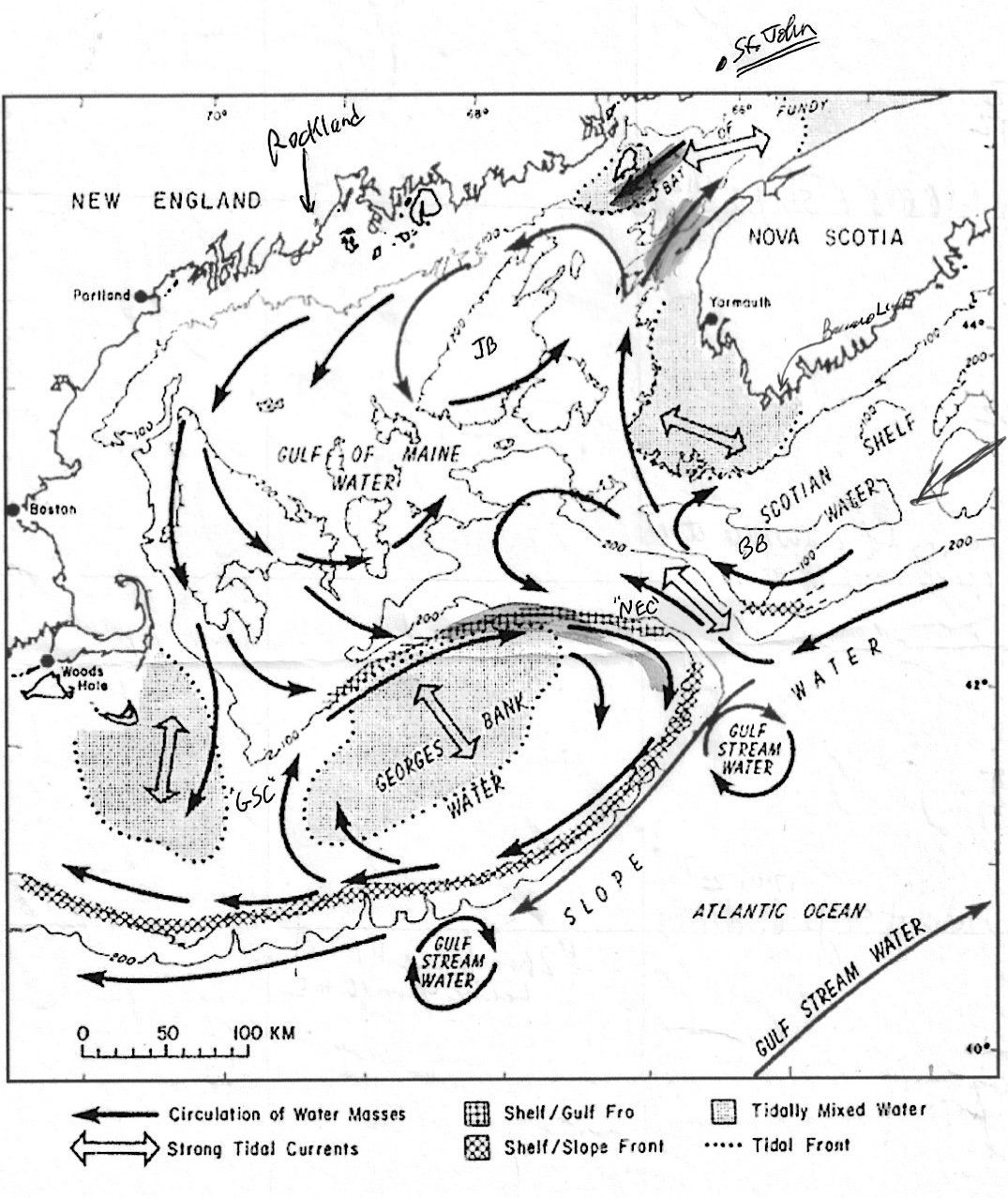
Our Major Sponsors

The Salty Dawg Sailing Association is a 501(c)(3) nonprofit educational and charitable organization.
QUICK LINKS
© Copyright 2020 Salty Dawg Sailing Association. All rights reserved.